
Conservation Practices or Best Management Practices (BMPs)
In Wisconsin, Best Management Practices (BMPs) are a set of guidelines and practices used to protect water quality, soil, and other natural resources, particularly for lake management and agricultural settings. These practices are designed to minimize the impact of human activities on the environment, including nonpoint source pollution like sediment runoff and erosion. The Winnebago County Land & Water Conservation Department works with landowners and farmers to assist with installation of BMPs, providing technical and financial assistance.
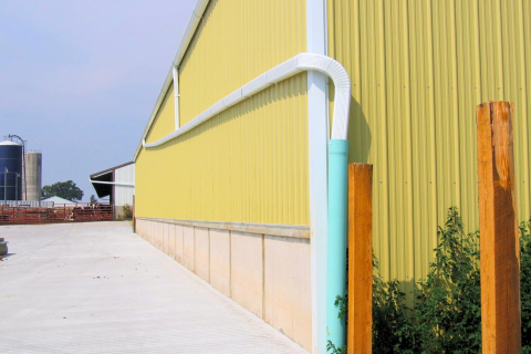 Barnyard Runoff Control SystemThe use of structural measures such as gutters, downspouts and diversions to intercept and redirect surface runoff around the barnyard, feeding area or farmstead, and collect, convey and temporarily store runoff from the barnyard, feeding area or farmstead. |
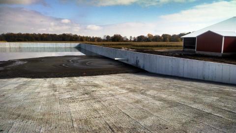 Manure Storage SystemA manure storage system is an impoundment made by constructing an embankment, excavating a pit or dugout, or by fabricating a structure to temporarily contain manure and other animal or agricultural wastes. These systems protect water quality by preventing runoff from animal lots, cutting fertilizer costs and preventing nutrient losses in agricultural fields, and allowing for manure to be safely stockpiled until conditions are environmentally safe for spreading. |
Nutrient Management PlanA Nutrient Management Plan is a tool to increase the efficiency of all the nutrient sources your crop uses while reducing production and environmental risk, ultimately increasing profit.
SnapPlus is a Nutrient Management Planning software program designed for the preparation of nutrient management plans in accordance with Wisconsin's Nutrient Management Standard Code 590. SnapPlus will calculate:
|
Rain GardensWhat is a Rain Garden? Rain gardens are landscaped areas planted with wild flowers and other native vegetation that soak up rain water from the roof of a house or other building. After a storm, the rain garden fills up with a few inches of water and slowly infiltrates into the soil. This reduces the amount of water running off the ground . What is a Rain Garden? Rain gardens are landscaped areas planted with wild flowers and other native vegetation that soak up rain water from the roof of a house or other building. After a storm, the rain garden fills up with a few inches of water and slowly infiltrates into the soil. This reduces the amount of water running off the ground and into a storm drain. A rain garden allows about 30% more water to soak into the ground than a conventional lawn. Why are Rain Gardens Important?
James P Coughlin Center Rain Garden Tour Installed in 2018, the Rain Garden takes drainage from about 6,000 square feet of the Coughlin Center's roof. During a 1 inch rainfall, this is 3,700 gallons of rain water. Rain Gardens are designed to keep rainwater, and the pollution it may carry, from eventually flowing into Lake Winnebago. Plus, they are beautiful gardens with a variety of plants that attract and provide a healthy habitat for birds, bees and butterflies! With roots growing down twice as deep as the plants are tall, the NATIVE PLANTS used in this garden are great at soaking up water.
|
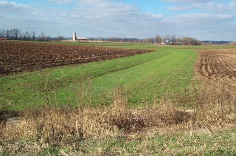
 Shoreline Habitat RestorationThe practice of restoring the healthy transition between land and water. This would consist of a shoreland buffer zone typically 20-35 ft. wide which is a mixture of native species that include grasses, forbs, shrubs and trees.
|
Soil HealthA cover crop is grass, legume, forb or other herbaceous plant that are established for seasonal cover and conservational purposes. The practice may be used to reduce wind or water erosion by establishing cover after a minimal residue crop. Cover crops are planted to use up excess nutrients in the soil profile, for weed suppression, to provide nutrients to the next crop, to increase carbon sequestration and improve soil structure. They are excellent tools for helping to improve soil health.
No-till farming (also known as zero tillage or direct drilling) is an agricultural technique for growing crops or pasture without disturbing the soil through tillage. No-till farming decreases the amount of soil erosion tillage causes as well as increase in the amount of water that infiltrates into the soil, soil retention of organic matter, and nutrient cycling. Cover Crops A cover crop is grass, legume, forb or other herbaceous plant that are established for seasonal cover and conservational purposes. The practice may be used to reduce wind or water erosion by establishing cover after a minimal residue crop. Cover crops are planted to use up excess nutrients in the soil profile, for weed suppression, to provide nutrients to the next crop, to increase carbon sequestration and improve soil structure. They are excellent tools for helping to improve soil health. Soil Health Challenge The Winnebago County “Soil Health Challenge (SHC)” is a program designed to reward participants that are willing to work with the Land and Water Conservation Department (LWCD) to commit a portion of their cropland to no-till farming coupled with well managed cover crops in an effort to educate themselves and other producers on the many benefits of improved soil health.
|
Streambank and Shoreline ProtectionVegetation, rock, or structures used to stabilize and protect the banks of streams, lakes, estuaries or excavated channels against scour and erosion and reduce sediment delivery to the water body. 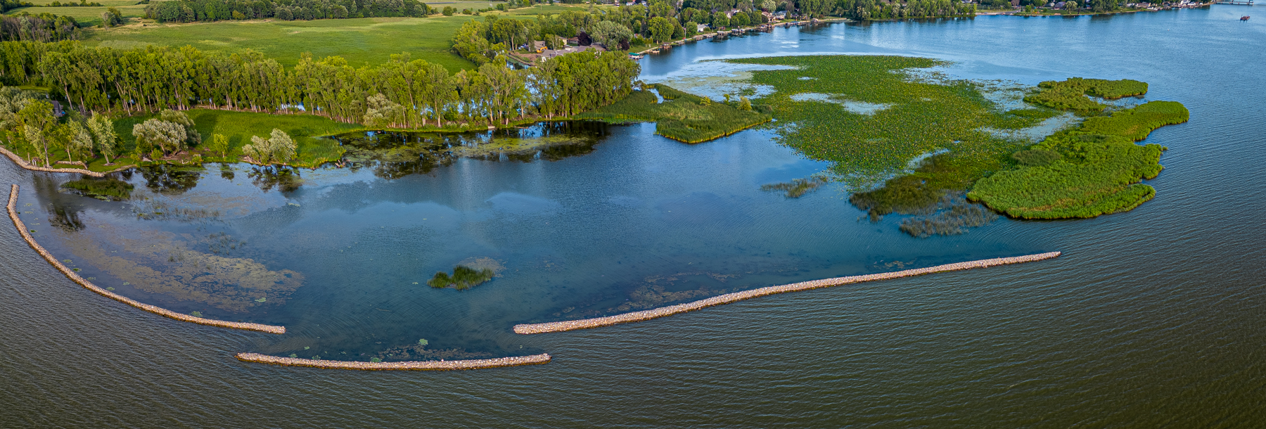 Photo: Stabenow Breakwall, Credit: Tim McEnroe, August 2023 Since 1941, the damage done at the Stabenow site by high water, waves, and ice has resulted in an average lateral recession of up to 2.5 feet of wetland per year, resulting in increased turbidity and loss of fish and wildlife habitat. Off-shore breakwalls were designed by the Winnebago County Land & Water Conservation Department (LWCD) and installed by local contractors to reduce sediment re-suspension within the habitat restoration area by reducing wave size and protecting the shoreline of the emergent marsh from further erosion. To determine the efficacy of the breakwall structures, the LWCD has been monitoring to determine the regrowth of aquatic plants, both emergent and submergent species. The aquatic plant monitoring comparison from 2021 to 2023 at the site has shown an overall impressive plant response in greater densities and species diversity.
|
 Waterway SystemA natural or constructed drainageway or channel shaped, graded and established in suitable cover as needed to prevent erosion by runoff waters. |
Well AbandonmentOld wells that are left open and/or unused are at risk of having contaminants enter into them and into the groundwater. Old drilled wells can develop cracks in the steel casing that can let contaminants through.
Old wells that are left open and/or unused are at risk of having contaminants enter into them and into the groundwater. Old drilled wells can develop cracks in the steel casing that can let contaminants through. Old dug wells were often lined with brick or field stone which does not provide a good barrier to prevent contaminants from reaching groundwater. Once contaminants reach the groundwater, it is difficult, if not impossible to remove them. Often the contamination will migrate to other wells drawing water from that aquifer. Old and unused wells may also pose a safety hazard. Old dug wells can be 6 feet across and 50 feet deep or deeper. Serious injury or worse could result if a person or animal fell into an old well. How Do I Get Started? The following describes the steps landowners must follow in order to receive cost sharing for a well abandonment project under this program. 1) The well owner applies for cost sharing from Winnebago County LWCD. WQIP - Application 2) The well owner requests a cost estimate for the well abandonment project from a Licensed Well Driller or Pump Installer (service provider). NOTE: If the first estimate exceeds $500.00, a second estimate is required. 3) A copy of the cost estimate is submitted to the Winnebago County LWCD for review. The LWCD reviews the project and determines eligibility for cost sharing. 4) If the project is eligible for cost sharing, a “Cost Share Agreement” (CSA) must be signed by all necessary parties and approved before any work is done on the well abandonment project. Well owners that do not have a signed and approved CSA prior to beginning their project will be denied cost sharing. 5) Once the project is completed, the well owner pays the service provider in full and requests a signed and dated receipt indicating the amount paid or the invoice marked “Paid in Full” signed and dated. The service provider must also properly complete and sign a WDNR Well Abandonment Form 3300-005 and give a copy to the well owner. 6) The well owner submits these documents to the LWCD for review and reimbursement in accordance with the CSA. What is Cost Sharing? Cost Sharing is financial assistance to pay for a portion of the project. The Winnebago County Land and Water Conservation Department has state and local funding sources used for cost sharing the installation of conservation practices, such as, well abandonment projects. Well abandonment projects will be ranked as a high or low resource concern and cost-shared as follows:
A well located in an area with a low potential to allow pollutant loading into the groundwater as determined by the LWCD shall be deemed a low resource concern well. Well abandonment projects need to be completed by a licensed well driller or pump installer to be eligible for cost sharing. For more information please contact the Winnebago County Land and Water Conservation Department or at the DNR website.
|
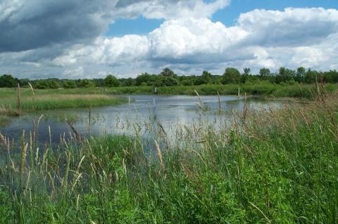 Wetland RestorationConstruction of berms or the destruction of tile line or drainage ditch functions to create conditions suitable for wetland vegetation. What is a Wetland Restoration? Wetland Restorations are incredibly effective conservation practices because of the multifunctional values they provide. They protect water quality by removing sediment and nutrients from runoff AND provide habitat for a multitude of wildlife. Restorations may include construction of berms, excavation for ponds or the destruction of tile line or drainage ditch functions to create conditions suitable for wetland vegetation. Click to enlarge example photos below. Wetland Restoration Demonstration at the James P Coughlin Center |

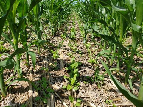 No-Till
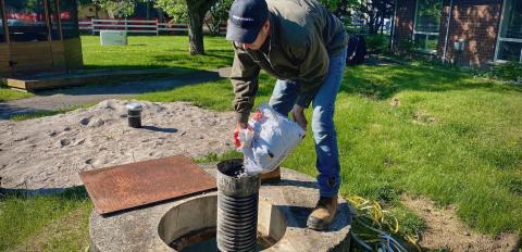 Why Should I Properly Abandon My Old Well?