
-
Open the GIS/Maps Parcel Viewer at: https://wcgis3.co.winnebago.wi.us/parcelviewer/
-
To find a parcel click in the search box and type in a parcel number (PIN), or Site Address.

-
Click the best matching result.
-
The map will zoom to the parcel. Verify it is the correct parcel.
-
-
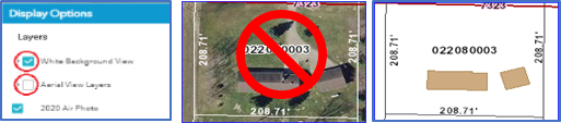
Click the display option button in the upper right corner.

-
Uncheck the Aerial View Layers and check the White Background View.
-
This will remove the aerial background from the map.
-
The aerial background makes the site plan hard to read and hard to scan
-
-
To print or export your map, click the print button.

- Select a layout type that is no larger than 11 x 17.
- Letter ANSI A Landscape – 8.5 inches by 11 inches
- Letter ANSI A Portrait – 8.5 inches by 11 inches
- Tabloid ANSI B Landscape – 11 inches by 17 inches
- Tabloid ANSI B Portrait – 11 inches by 17
- Click the print button to generate a pdf map.


- When the pdf is finished creating, click on the map title.
- This will open the document in your pdf viewer.
- If the map covers the area you need for your site plan, you can print the map from your pdf viewer.
- If the map does not cover the area you need, move the map on the parcel viewer screen and generate a new pdf map.
- You can print from your pdf viewer or download to use later.
Search
Copyright © 2025 Winnebago County Government - Wisconsin.